3D Photogrammetry Models & Drone 3D Mapping | Collin County Drone – North Texas
Collin County Drone Services creates precise 3D photogrammetry models and 2D orthomosaic maps using hundreds of overlapping aerial photos processed with professional photogrammetry software. These detailed, measurable 3D models give builders, developers, and property owners in Celina, Frisco, Prosper, McKinney, and the entire DFW metroplex the clear visuals they need for planning, bidding, and progress tracking.
Why Choose Drone 3D Photogrammetry Models from Collin County Drone
- Survey-grade 3D models and orthomosaic maps
- Ideal for construction progress, stockpile volumes, and site planning
- Faster and more affordable than traditional surveying
- 48-hour turnaround on most projects
- Transparent pricing with $500 off your first project
How Our 3D Photogrammetry Process Works
Our FAA-certified pilots capture hundreds of high-resolution photos during a single flight. These images are then processed using advanced photogrammetry software to stitch them into accurate 2D orthomosaic maps and fully measurable 3D models. The result is a digital twin of your site that can be viewed, measured, and shared in AutoCAD, Civil 3D, or any standard viewing software.
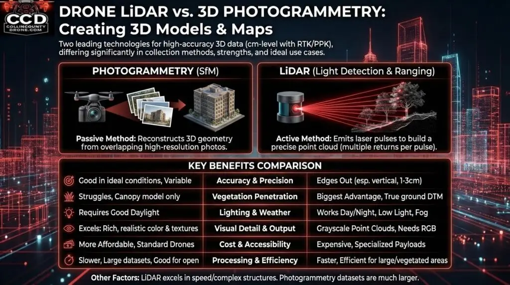
3D Photogrammetry vs Drone LiDAR – When to Choose Each
While LiDAR excels at penetrating dense vegetation for bare-earth data, 3D photogrammetry is often the better and more cost-effective choice for finished construction sites, architectural visualization, and high-detail surface modeling. We’ll recommend the right technology for your specific project.
Ready for Professional 3D Photogrammetry Models in Collin County?
Whether you need a single-acre site model or full-project 3D mapping, our family-owned team is ready to deliver. Get same-day quotes, $500 off your first 3D photogrammetry project, and fast 48-hour delivery. Call 972-314-9500 or request your free quote today.