Drone Industry Insights: LiDAR, Photogrammetry & Construction in North Texas
Aerial data for North Texas builders, surveyors, and developers
Collin County and the greater DFW metroplex are in one of the fastest construction and real estate booms in the country. Billion-dollar mixed-use developments, new campuses, and thousands of new homes are rising across Celina, Frisco, McKinney, Prosper, and Plano. Builders, surveyors, and developers need site data that holds up under review and shows up fast enough to keep decisions moving. Ground crews and manned aircraft cannot match the pace and scale of today's projects.
Professional drone services fill the gap. Our drone LiDAR mapping delivers survey-grade accuracy and penetrates dense vegetation that photogrammetry cannot map. Our 3D photogrammetry models produce measurable, client-ready deliverables for planning, permitting, and marketing. Job-site inspections and recurring progress flights keep projects on schedule and on budget. Pricing is transparent through our online pricing calculator, often 60-80% less than traditional methods, with 48-hour turnaround from flight to deliverable.
Below are field notes, case studies, and practical insights from our FAA Part 107 licensed team, written for the builders, surveyors, and developers working across North Texas.
A Community Tested: Surviving the Atoka County Tornado in Caney, Oklahoma Tuesday, April 28, 2026, started as a typical spring day for the residents of
Click here for instant pricing calculator Drone Services for Construction Project Managers: Weekly Aerial Progress, As-Builts, and Documentation in 48 Hours Your superintendent should not
@import url(‘https://fonts.googleapis.com/css2?family=Raleway:wght@400;500;600;700;800&display=swap’); .ccd-article, .ccd-article p, .ccd-article li, .ccd-article td, .ccd-article th, .ccd-article h1, .ccd-article h2, .ccd-article h3, .ccd-article blockquote { font-family: ‘Raleway’, sans-serif; } .ccd-article
Drone LiDAR and Photogrammetry for Land Surveyors: Survey-Grade Deliverables in 48 Hours If you are a licensed land surveyor in North Texas, the question is
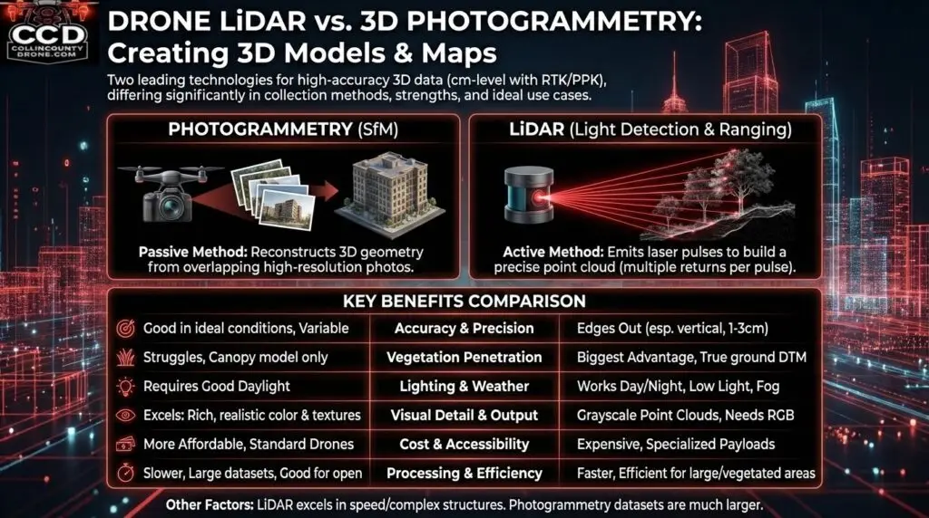
Understanding Drone Photogrammetry (Best for Construction & Visual Mapping) Drone LiDAR vs. 3D Photogrammetry: Choosing the Right Drone Mapping Solution in North Texas Drone surveying
Drone LiDAR for Real Estate Development: Faster Surveys, Lower Costs, and Smarter Site Decisions Real estate developers are increasingly using drone-mounted LiDAR (Light Detection and
Key Benefits of Drone LiDAR for Surveyors Drone LiDAR Reshapes Land Surveying with Hybrid Precision The land surveying industry is undergoing a technological shift as
Drone Image Ice Storm How Drones Can Help with Recovery from an Ice Storm Faster Recovery, Safer Inspections, Smarter Decisions Supporting Utility Recovery and Infrasturcture
Why LiDAR? Drone LiDAR Services for Construction, Utilities, and Earthworks Drone LiDAR captures survey-grade 3D data through trees, in complex terrain, and at night. If